When you configure the ArcGIS Map Web Part, you can add data to the map from several different sources. Single sets of data that are added to the Map Web Part are rendered on the client using the graphic feature display and rendering capabilities included with the ArcGIS API for Microsoft Silverlight. SharePoint lists, data tables made available through a MapIt Spatial Data Service, layers in an ArcGIS Server map service, InfoPath form libraries, and Microsoft Office document libraries are examples of single datasets that are rendered on the client. When adding data from ArcGIS Server, you also have the option to add map services as map service layers. Such layers are rendered as map images on the server using the symbology specified by the service, and then blended with other map data on the client.
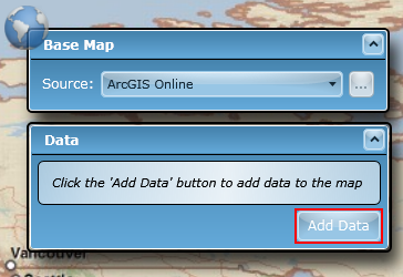
To add data, click the Add Data button on the Data dialog:
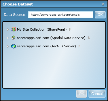
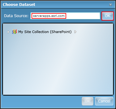
The Add Data dialog that appears permits you to add geographic datasets from the following sources:
| Data Source | Description | Available Data Sets |
Url Format |
|---|---|---|---|
| SharePoint site |
Contains SharePoint lists with geographic columns. All sites within the current SharePoint server farm to which the logged in user has permission can be specified. |
SharePoint lists, including InfoPath forms libraries and Word document libraries | http://<web application>/<site path> Examples: http://sedona:1234/ http://sedona:1234/sites/mySite |
| ArcGIS Server instance | References ArcGIS Server map services and layers in an ArcGIS Server instance. The ArcGIS Server REST API is used to communicate with the ArcGIS Server, thus the REST endpoint must be used when connecting to a server. | ArcGIS Server map services and individual layers within those services | http://<host name>/<AGS instance name>/rest/services Example: http://serverapps.esri.com/arcgis/rest/services The default path for an ArcGIS Server instance is http://<web server>/arcgis/rest/services. If the path after the host name is not included, the Map Web Part will automatically append the default path and discover services. |
| MapIt Spatial Data Service | References a SQL Server instance's databases and tables. Each table must have a geometry column. The MapIt Spatial Data Service is used to communicate with the SQL Server instance. | SQL Server tables that have been spatially enabled with MapIt | http://<host namer>/<SDS instance name>/databases Example: http://sedona:82/sds/databases The default path for a MapIt service instance is http://<web server>/sds/databases. If the path after the Web server name is not included, the Map Web Part will automatically append the default path and discover databases and tables. |
Once you have made a successful connection to one of the data sources listed above, the source will be listed in the Add Data dialog. Each data source can be expanded to view the geographic datasets that it contains. A hover menu is also available to the right of each data source that allows you to remove the source or refresh its contents. To help you distinguish between data source types, each data source is shown with a type-specific icon and descriptive text: