When you create any cache that will be used with an ArcGIS Data Appliance cache in the .NET Web ADF, the following items are important to note:
You will achieve the fastest performance when your map is in the same coordinate system as the maps on the ArcGIS Data Appliance, which is WGS_1984_Web_Mercator. If you choose to not use this coordinate system, one of the maps will need to be projected on the fly, thereby slowing performance.
To set the coordinate system of your map to WGS_1984_Web_Mercator:
All of the data in your map will be projected on the fly to this coordinate system. When you cache the map, it will be cached in this coordinate system.
When overlaying map caches using the .NET Web ADF, the caches must have the same tile origin and tile size. This means that if you are creating a map cache that will overlay a cache from the ArcGIS Data Appliance, you must match your tile origin and tile size to the ones used on the Appliance. The caches on the Appliance are built with the following parameters:
Tile origin: -180, 85
Tile size: 256 X 256
You will achieve the performance benefit of both caches only when the two caches have matching scale levels. In the case of a scale level gap (when a scale level exists in one cache but not another), the overlaying image cannot be pulled from the cache and must be generated dynamically, thereby slowing performance. Image quality will also be degraded in this scenario because the dynamic image must be resampled from one of the existing scale levels.
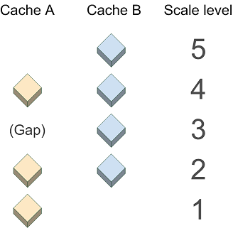
In the diagram below, Cache A does not exist at Scale 3, therefore the .NET Web ADF will generate a dynamic image to overlay the image from Cache B at this scale.
Dynamic images are not created to match scales beyond the top or bottom scale of the cache. Therefore, for Cache A, a dynamic image will not be generated at Scale 5. Instead, Cache A will not be visible at Scale 5; only the cached image from Cache B will be displayed. Similarly, at Scale 1, only Cache A will be visible.
Many of the caches on the ArcGIS Data Appliance have worldwide coverage at a large variety of scales. You do not need to create your cache using all of these scales, but where possible the scale levels you use should match the ones used in the appliance caches.
Following is a list of the scales used on the ArcGIS Data Appliance. Each cache uses all of these scales or a sequential subset of them. (The high-precision values of the scales are necessary for the caches with worldwide coverage to appear seamless at 0 degrees longitude.) When building any cache that will overlay a cache from the appliance, you should match the values exactly, so that you can get the performance benefit of both caches. For instructions on how to create a map cache that uses these scales, see the Create a Map Cache section in Designing a map to overlay Google Maps or Microsoft Virtual Earth in the ArcGIS Server .NET Help.
The basemap caches on the ArcGIS Data Appliance use the JPG image format, while the reference caches use 8-bit PNGs. (You can use the Directory of Services to learn which caches are considered basemaps and which are reference.) Although the JPG format displays faster than other formats, it does not support transparency. Therefore, any basemap caches on the appliance will obscure layers that are placed beneath them. Similarly, if you create your own JPG cache, you will not be able to see any layers you place beneath it.
In .NET Web applications containing more than one map service, the Primary Map Resource determines which service will supply the coordinate system and zoom levels of the map. You may have noticed that when you build a Web application in Manager, there is a dropdown menu labeled "Use coordinate system and extent of:". The service you select here becomes the Primary Map Resource. If you use Visual Studio to build your Web applications, the Primary Map Resource is a property of the Map control. Follow these guidelines for setting the Primary Map Resource: