
In this installation scenario, you install the OGC Interoperability feature for WFS and/or WMS. The WMS feature for ArcIMS enables ArcIMS to work within the OGC WMS (Open Geospatial Consortium standard Web Map Service) specification. The WFS feature for ArcIMS enables ArcIMS to work within the OGC WFS (Open Geospatial Consortium standard Web Feature Service) specification.
|
Tip
|
Verify your site meets system requirements. For system requirement information see Step 1: Verify system requirements
Log in as a user with administrator privileges.
Close all applications on your computer.
Insert the ArcIMS media into the appropriate drive to automatically launch the setup program.
During the installation you will be asked to read the license agreement and accept it, or exit if you don't agree with the terms.
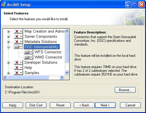
At the Select Features dialog box, expand the OGC Interoperability feature by clicking on the + sign to view the sub-features. The OGC Interoperability feature contains the WMS, and WFS sub-features. Click the dropdown arrow to the left of the OGC Interoperability sub-feature that you would like to install. From the list, select Will be installed on local hard drive to install the selected OGC Interoperability feature.
To complete the installation, follow the directions on your machine.
Complete the post installation setup.
The following ArcIMS post installation option is required to successfully install OGC Interoperability:
Web server-Servlet Engine configuration.
Additional configuration steps for OGC Interoperability
Before the installation is complete, configure the OGC Interoperability feature you installed: