
B U S I N E S S A N A L Y S T 10.2 R E S T T R A D E A R E A T A S K
Drive Time Endpoint
Creates trade areas based on the driving time or driving distance around store features.
Availability: Business Analyst Online, Business Analyst Server.
URL Example
http://localhost:6080/arcgis/rest/services/DefaultMap/MapServer/exts/BAServer/DriveTime/execute
Specific Parameters
Parameter |
Description |
|---|---|
DistanceUnits (required) |
The time or distance units of the Radii property which is used to calculate the drive time trade/service areas. Type esriBADriveTimeUnits. |
Radii (required) |
Array of drive time times or distances, in ascending size, in the units specified in the DistanceUnits property. Type array of double. |
Stores (required) |
A point layer containing point features such as businesses, hospitals, schools, etc. which represent the locations from which the drive time trade/service areas will originate. Type PointLayer. |
AnalysisExtent (optional) |
Data extent to restrict the analysis. Type ExtentData. |
BuildNonOverlappedDriveTimes (optional) |
An option specifying creation non-overlapped areas, using Thiessen polygons. Type boolean. Default: false. |
CreateDetailedBorder (optional) |
An option specifying creation a detailed border, ignoring areas that cannot be driven to. Type boolean. Default: false. |
Donut (optional) |
An option specifying creation of donut-style drive time trade/service areas instead of areas that all originate from the store/business point origins. Type boolean. Default: false. |
SingleStoreID (optional) |
ID of a single store in the Stores layer to generate drive time or distance areas. Type string. |
StoreIDField (optional) |
The attribute field name in the input Stores layer which is associated with unique store/business IDs (typically store numbers for retail establishments with multiple locations). Type string. Default: STORE_ID. |
Other Parameters
Parameter |
Description |
|---|---|
OutputType (required) |
Array of task output options. Options for this endpoint include rendering an output image (GetMapImage), creating a feature layer for subsequent analysis (GetFeatureClass), and creating a report (GetReport). Type array of TaskOutputType. |
ActiveDatasetID (optional) |
ID of the active dataset. Type string. Default: ID of the first available dataset. |
DataHierarchy (optional) |
Name of a hierarchy of data layers used for generating summary reports. Type string. Use the Get Data Hierarchies lookup operation to query available geography hierarchies. Default: Standard Business Analyst Data. |
f (optional) |
Response format. Type string. Available formats: HTML, JSON, PJSON, XML. Default: HTML. |
IsFullErrorMessage (optional) |
Mode for composing error messages. Type boolean. Default: false. |
OutputAnalysisItem (optional) |
Configuration options for storing the output feature layer in the repository. This will enable viewing and working with the output result in subsequent tasks. Type esriFolderItem. |
OutputReportItems (optional) |
Array of configuration options for storing the output reports in the repository. This will enable viewing and working with the output results in subsequent tasks. Type array of esriFolderItem. |
OutputSpatialReference (optional) |
An option specifying the spatial reference to return the output feature layer. Type SpatialReference. If this parameter is missing, the output record set will be returned in the default spatial reference. See Get Default Spatial Reference lookup operation to query the default spatial reference. |
RenderingParameters (optional) |
Configuration options for rendering output when GetMapImage option is specified in the OutputType parameter. Type RenderingParameters. |
ReportOptions (optional) |
Array specifying summary reports that will be generated using trade/service areas as boundary areas for analysis. Use the Get Report Templates lookup operation to query available report templates. Type array of ReportOptions. |
ReturnGeometry (optional) |
An option specifying the presence of the shape attribute in the returned record set. Type boolean. Default: true. |
token |
Authentication token. In Business Analyst Server, this parameter is required if your Business Analyst Server is secured. Type string. |
Returns
Variable of type TaskResultOutput
Remarks
Equal competition market areas do not adjust for the way people actually travel. Equal competition market areas are based on as the crow flies distances, while people use roads and streets. A two mile trip might take five minutes on one road and 15 minutes on another.
Using the Drive Time endpoint, you can generate the drive time areas that use actual street networks and approximated driving times.
The analysis can be restricted to an analysis extent if the AnalysisExtent parameter is specified. The optional SingleStoreID parameter restricts the analysis to a single store of the store layer. The drive time/distance areas can be generated with detailed borders if CreateDetailedBorder parameter is true. If BuildNonOverlappedDriveTimes parameter is true, an overlap between drive time/distance areas is removed using Thiessen (equal competition) polygons approach.
NOTE 1: Since Business Analyst Server 10.0, the SummaryDataLayerID parameter is replaced with an optional DataHierarchy parameter.
NOTE 2: Since Business Analyst Server 10.0, the OutputReportItem parameter is replaced with the OutputReportItems parameter which is an array of folder items. The number of items in this array should be equal to the number of items in the ReportOptions array.
How Does it Work
Pizza delivery provides a good case example for the use of drive time polygons. A company may want to limit deliveries to a total of 15 minutes. This means that the delivery radius of each store would be restricted to a 6 minute drive time (six minutes to the delivery point, three minutes at the delivery site, and six minutes to return, for a total of 15 minutes).
Overlap can occur. Some store chains solve this problem by using equal competition areas where drive time overlap occurs, to make each service zone unique and using the drive times at the edge of the built up urban areas to restrict delivery distances and times.
Other examples of drive time areas include:
• Drive time is the defining measure for most urban travel. Potential customers respond much better to a location advertised as being within 5 minutes than one within 2 miles.
• Appliance repair operations use drive time polygons to estimate the total length of their service calls.
• Stores place locations so that at least some minimum population is within 5 minutes of each store. The threshold population is also dependent on the number and location of competitors within each drive time trade area (polygon).
Usage Tips
• The spatial reference of the output feature layer will be the same as the store layer.
• Drive time distances should be limited to 90 minutes. Realistic analyses beyond this threshold should be run using simple rings.
• The drive time center input feature layer must be point features.
• In most cases, the drive time center input feature layer will be a Business Analyst store layer.
• Valid numeric distances must be used when defining drive time values. Negative distances cannot be used.
• The Donut option creates output polygons that are bands. For example, if three radii are entered with values of 1, 3, and 5 minutes, three output bands would be created with 0–1, 1–3, and 3–5 minute drive time trade areas.
• Set the measure units to minutes if you want to create drive time trade areas.
• To compensate for traffic patterns in drive time analyses, adjust driving distances accordingly. For example, if you are looking at a time of day when traffic patterns are heavy (such as rush hour) and the drive time takes twice as long, then you can halve the drive time to reflect this pattern.
• The CreateDetailedBorder option allows you to draw drive time boundaries that will ignore areas that cannot be driven to. This may create holes in your drive time boundary file. This option is ignored by Business Analyst Server if its street map solver doesn't support detailed borders.
Example Usage
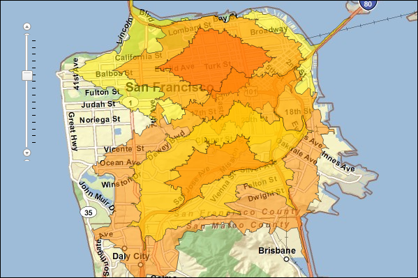
The example below illustrates a workflow which includes generation of a drive time-based trade area around a store location and the creation of a report based on this trade area.
Response
{
  "results":
  [
    {
      "paramName":"OutputFeatureClass",
      "dataType":"GPFeatureRecordSetLayer",
      "value":
      {
        "geometryType":"esriGeometryPolygon",
        "spatialReference":
        {
          "wkid":4326
        },
        "fieldAliases":
        {
          "FID":"FID",
          "AREA_ID":"AREA_ID",
          "STORE_ID":"STORE_ID",
          "RING":"RING",
          "RING_DEFN":"RING_DEFN",
          "AREA_DESC":"AREA_DESC",
          "AREA_DESC2":"AREA_DESC2",
          "AREA_DESC3":"AREA_DESC3",
          "STORE_LAT":"STORE_LAT",
          "STORE_LONG":"STORE_LONG",
          "Latitude":"Latitude",
          "Longitude":"Longitude",
          "NAME":"NAME",
          "DESCR":"DESCR",
          "STORE_ADDR":"STORE_ADDR"
        },
        "fields":
        [
          {
            "name":"FID",
            "type":"esriFieldTypeOID",
            "alias":"FID"
          },
          ...
          {
            "name":"STORE_ADDR",
            "type":"esriFieldTypeString",
            "alias":"STORE_ADDR",
            "length":254
          }
        ],
        "features":
        [
          {
            "geometry":
            {
              "rings":
              [
                [
                  [
                    -122.434392727273,
                    37.8067581818181
                  ],
                  ...
                  [
                    -122.434392727273,
                    37.8067581818181
                  ]
                ]
              ],
              "spatialReference":
              {
                "wkid":4326
              }
            },
            "attributes":
            {
              "FID":0,
              "AREA_ID":"1_3",
              "STORE_ID":"1",
              "RING":3,
              "RING_DEFN":"7 minutes",
              "AREA_DESC":"0 - 7 minutes",
              "AREA_DESC2":"Drive Time: 7 minutes",
              "AREA_DESC3":"Drive Time: 3, 5, 7 minutes",
              "STORE_LAT":37.784298,
              "STORE_LONG":-122.434616,
              "Latitude":37.7842981345,
              "Longitude":-122.434615846,
              "NAME":"store1",
              "DESCR":"Store 1",
              "STORE_ADDR":"Address 1"
            }
          },
          ...
          {
            "geometry":
            {
              "rings":
              [
                [
                  [
                    -122.432329767939,
                    37.7433548850039
                  ],
                  ...
                  [
                    -122.432329767939,
                    37.7433548850039
                  ]
                ]
              ],
              "spatialReference":
              {
                "wkid":4326
              }
            },
            "attributes":
            {
              "FID":5,
              "AREA_ID":"2_1",
              "STORE_ID":"2",
              "RING":1,
              "RING_DEFN":"3 minutes",
              "AREA_DESC":"0 - 3 minutes",
              "AREA_DESC2":"Drive Time: 3 minutes",
              "AREA_DESC3":"Drive Time: 3, 5, 7 minutes",
              "STORE_LAT":37.733343,
              "STORE_LONG":-122.432871,
              "Latitude":37.7333425483,
              "Longitude":-122.432871162,
              "NAME":"store2",
              "DESCR":"Store 2",
              "STORE_ADDR":"Address 2"
            }
          }
        ]
      }
    },
    {
      "paramName":"Age by Income Profile.PDF",
      "dataType":"GPDataFile",
      "value":
      {
        "url":"http://localhost/arcgisoutput/_ags_T6859767FF4B01AD8D6B8D2AE097FD.pdf"
      }
    }
  ],
  "messages":
  [
  ]
}
NOTE: The response has been abbreviated where "..." is noted.
JSON Response Example Rendered with the ArcGIS API for JavaScript
See Also