


 Object Model
Syntax
Remarks
The GeographyLevelID parameter specifies the geography level whose geographic units are exported to the output trade area.
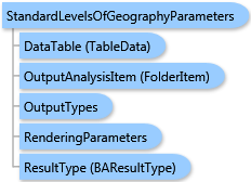
There are two ways for selecting IDs of geographic units from the geography level—using an array of IDs or using a data table.
In the first case, the GeographyIDs parameter explicitly specifies the list of IDs of geographic units.
In the second case, the DataTable parameter specifies a data table and the TableIDField parameter specifies the column of the data table which contains the geography IDs required.
Output options for this task include rendering an output image (OutputTypes.GetMapImage), creating a feature class for subsequent analysis (OutputTypes.GetFeatureClass), and/or creating a report (OutputTypes.GetReport). If no output options are specified, the required output options are specified as follows. If the RenderingParameters parameter is specified, the image output is requested. If the ReportOptions parameter is specified, the report is requested. If the OutputAnalysisItem parameter is specified, the output analysis feature class will be stored in the repository. If RenderingParameters, ReportOptions, and OutputAnalysisItem parameters are missing, the feature class output is requested.
Example
| C# |  Copy Code Copy Code |
|---|---|
StandardLevelsOfGeographyParameters parameters = new StandardLevelsOfGeographyParameters(); // Set a geography level ID. parameters.GeographyLevelID = "US.ZIP5"; // Explicitely specify geography IDs in a list. parameters.GeographyIDs = new List<string>() { "92373", "92374" }; // Set report options. ReportOptions options = new ReportOptions("PDF", "Age by Income Profile"); options.Header = new ReportHeader("Report for Redlands ZIP Codes"); parameters.ReportOptions = new List<ReportOptions>(){ options }; standardLevelsOfGeographyTask.ExecuteAsync(parameters, new AsyncResponder(resultHandler, faultHandler)); | |
Inheritance Hierarchy
System.Object
ESRI.ArcGIS.Client.BACore.Client.BATaskParameters
ESRI.ArcGIS.Client.BACore.Client.SummaryReportParameters
ESRI.ArcGIS.Client.BAServer.Tasks.TradeAreas.TradeAreaTaskParameters
ESRI.ArcGIS.Client.BAServer.Tasks.TradeAreas.StandardLevelsOfGeographyParameters
Requirements
Target Platforms: Windows 98, Windows NT 4.0, Windows Millennium Edition, Windows 2000, Windows XP Home Edition, Windows XP Professional, Windows Server 2003 family, Windows Vista, Windows Server 2008 family