


 Object Model
Syntax
Remarks
The CenterMethod parameter specifies a way to identify center points of trade areas of the Boundaries layer—using area centroid (default) or using the location of the store the trade area is associated with. In the last case, the following parameters should be specified:
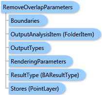
- the
AreaIDFieldparameter specifies a field in theBoundarieslayer containing the ID of the associated store (this is usually the "STORE_ID" field), - the
Storesparameter specifies the store layer, and - the
StoreIDFieldparameter specifies a field in theStoreslayer containing store ID.
The OverlapMethod parameter specifies a method for area overlap removing—using Thiessen polygons (default) or using grid.
The WeightMethod parameter specifies a weight method used by the grid overlap removing method. Default method is "use area".
Output options for this task include rendering an output image (OutputTypes.GetMapImage), creating a feature class for subsequent analysis (OutputTypes.GetFeatureClass), and/or creating a report (OutputTypes.GetReport). If no output options are specified, the required output options are specified as follows. If the RenderingParameters parameter is specified, the image output is requested. If the ReportOptions parameter is specified, the report is requested. If the OutputAnalysisItem parameter is specified, the output analysis feature class will be stored in the repository. If RenderingParameters, ReportOptions, and OutputAnalysisItem parameters are missing, the feature class output is requested.
Example
| C# |  Copy Code Copy Code |
|---|---|
RemoveOverlapParameters parameters = new RemoveOverlapParameters(); // The Boundaries type could take either data as // ESRI.ArcGIS.Client.Tasks.FeatureSet, ESRI.ArcGIS.Client.BAServer.FolderItem, // or ESRI.ArcGIS.Client.BACore.StandardLayer. parameters.Boundaries = featureSet; // Set ID of field in the Boundaries layer containing IDs of associated stores. parameters.AreaLinkField = "STORE_ID"; // OverlapRemoverCenterMethod.esriOverlapRemoverCenterMethodUseCentroid is the defualt value for CenterMethod. //parameters.CenterMethod = OverlapRemoverCenterMethod.esriOverlapRemoverCenterMethodUseCentroid; // OverlapRemoverOverlapMethod.esriOverlapRemoverOverlapMethodThiessen is the defualt value for OverlapMethod. //parameters.OverlapMethod = OverlapRemoverOverlapMethod.esriOverlapRemoverOverlapMethodThiessen; removeOverlapTask.ExecuteAsync(parameters, new AsyncResponder(resultHandler, faultHandler)); | |
Inheritance Hierarchy
System.Object
ESRI.ArcGIS.Client.BACore.Client.BATaskParameters
ESRI.ArcGIS.Client.BACore.Client.SummaryReportParameters
ESRI.ArcGIS.Client.BAServer.Tasks.TradeAreas.TradeAreaTaskParameters
ESRI.ArcGIS.Client.BAServer.Tasks.TradeAreas.RemoveOverlapParameters
Requirements
Target Platforms: Windows 98, Windows NT 4.0, Windows Millennium Edition, Windows 2000, Windows XP Home Edition, Windows XP Professional, Windows Server 2003 family, Windows Vista, Windows Server 2008 family