


 Object Model
Syntax
Remarks
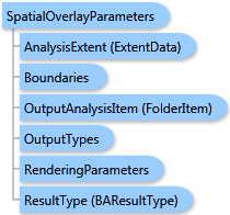
The analysis can be restricted to an analysis extent if the AnalysisExtent parameter is specified. The optional SingleAreaID parameter restricts the analysis to a single area.
The Summarizations parameter specifies names of variables from the data hierarchy to be aggregated on areas of the Boundaries layer and appended to the output feature class as attributes.
The ReturnGeometry option specifies how to return the analysis result in the FeatureSet property of the TaskResultOutput—with or without the shape attribute.
Output options for this task include rendering an output image (OutputTypes.GetMapImage) and/or creating a feature class for subsequent analysis (OutputTypes.GetFeatureClass). If no output options are specified, the required output options are specified as follows. If the RenderingParameters parameter is specified, the image output is requested. If the OutputAnalysisItem parameter is specified, the output analysis feature class will be stored in the repository. If both RenderingParameters and OutputAnalysisItem parameters are missing, the feature class output is requested.
Example
| C# |  Copy Code Copy Code |
|---|---|
SpatialOverlayParameters parameters = new SpatialOverlayParameters(); // The Boundaries type could take either data as // ESRI.ArcGIS.Client.Tasks.FeatureSet, ESRI.ArcGIS.Client.BAServer.FolderItem, // or ESRI.ArcGIS.Client.BACore.StandardLayer. // Set Boundaries with a valid data type. parameters.Boundaries = boundaries; // Set demographic variables to be aggregated to the output feature class. parameters.Summarizations = new List<string>() {"TOTPOP_CY", "HHPOP_CY"}; // Optionally restrict analysis to ExtendData object specified with myExtent. //parameters.AnalysisExtent = myExtent; spatialOverlayTask.ExecuteAsync(parameters, new AsyncResponder(resultHandler, faultHandler)); | |
Inheritance Hierarchy
System.Object
ESRI.ArcGIS.Client.BACore.Client.BATaskParameters
ESRI.ArcGIS.Client.BACore.Client.AnalysisParameters
ESRI.ArcGIS.Client.BAServer.Tasks.AnalysisParameters
ESRI.ArcGIS.Client.BAServer.Tasks.Analyses.SpatialOverlayParameters
Requirements
Target Platforms: Windows 98, Windows NT 4.0, Windows Millennium Edition, Windows 2000, Windows XP Home Edition, Windows XP Professional, Windows Server 2003 family, Windows Vista, Windows Server 2008 family