
The Definition tab of the Properties window enables you to set a dataset's display name, filter expression, transparency, and automatic update behavior. The ability to define a filter expression is exclusive to datasets that are served by an ArcGIS Server map service or a MapIt Spatial Data Service, while enabling and configuring automatic updates is only available for SharePoint lists.
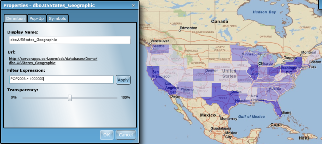
The image below shows the Definition tab as it appears when configuring layers that are served by an ArcGIS Server map service layers or tables that are made available via a MapIt Spatial Data Service. Notice that the dialog includes controls to configure a filter expression:
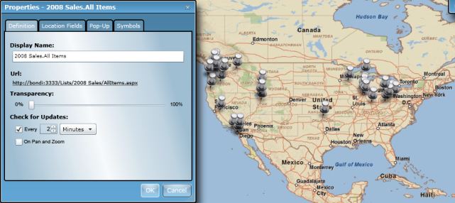
When configuring SharePoint lists, the Definition tab appears as shown below. Note that there is now a Check for Updates section and that there are no longer controls to define a filter expression:
The following table discusses the use of each property:
| Property | Description |
|---|---|
| Display name |
Defines the name of the dataset as it's displayed in the Data dialog during the use of the Map Web Part. See the Interact with data topic to see how datasets are presented in the user view of a Map Web Part. |
| Filter expression | An attribute query can be applied to a dataset to filter the data that is displayed. The filter expression consists of one or more phrases, where each phrase consists of a field, a query operator, and a value. Phrases can be connected using logical operators such as AND and OR. Basic SQL query operators are supported. Click the Apply button to apply the current filter expression to the dataset. The expression is applied such that records that satisfy the expression are included on the map. Filter expressions are not exposed for SharePoint lists. If you need to create a subset of a list, you can use SharePoint's ability to create a view that filters records from the source data. |
| Transparency | Sets the transparency of all features in a dataset. Use the slider bar to define the transparency value between 0 (opaque) to 100 (transparent). Changes are instantaneously applied to the layer in the map. |
| Check for Updates | SharePoint lists permit periodic checking for updated to list items. The following options are available: Check the "Every" box to have the Map Web Part check the list and update the features shown on the map at a specified interval. Use the textbox and drop-down menu to the right of the checkbox to specify the interval. If geographic coordinates for your SharePoint list were generated by locating addresses, the Map Web Part will use a locator service to determine and assign coordinates to new list items. Check the "On Pan and Zoom" box to have the Map Web Part check the list and update the features shown on the map any time the extent is changed. |