
B U S I N E S S A N A L Y S T 10.5 R E S T S E G M E N T A T I O N T A S K
Target Penetration Map Endpoint
Thematically shades the percent penetration of selected segments. This map helps you determine the concentration of your target segments at a given level of geography.
Availability: Business Analyst Server.
URL Example
http://localhost:6080/arcgis/rest/services/DefaultMap/MapServer/exts/BAServer/TargetPenetrationMap/execute
Specific Parameters
Parameter |
Description |
|---|---|
AnalysisExtent (required) |
Analysis extent. Type ExtentData. |
SegmentationBase (required) |
Segmentation base. Use the GetSegBases lookup operation to query available segmentation bases. Type string. |
SegmentationLevel (required) |
Segmentation level ID. Use the GetSegmentationLevels lookup operation to query available segmentation level IDs and names. Type string. |
SelectedSegments (required) |
Other Parameters
Parameter |
Description |
|---|---|
OutputType (required) |
Array of task output options. Options for this endpoint include rendering an output image (GetMapImage), creating a feature layer for subsequent analysis (GetFeatureClass), and creating a report (GetReport). Type array of TaskOutputType. |
ActiveDatasetID (optional) |
ID of the active dataset. Type string. Default: ID of the first available dataset. |
f (optional) |
Response format. Type string. Available formats: HTML, JSON, XML. Default: HTML. |
IsFullErrorMessage (optional) |
Mode for composing error messages. Type boolean. Default: false. |
OutputAnalysisItem (optional) |
Configuration options for storing the output feature layer in the repository. This will enable viewing and working with the output result in subsequent tasks. Type esriFolderItem. |
OutputReportItem (optional) |
Configuration options for storing the output report in the repository. This will enable viewing and working with the output result in subsequent tasks. Type esriFolderItem. |
OutputSpatialReference (optional) |
An option specifying the spatial reference to return the output feature layer. Type SpatialReference. If this parameter is missing, the output record set will be returned in the default spatial reference. See Get Default Spatial Reference lookup operation to query the default spatial reference. |
RenderingParameters (optional) |
Configuration options for rendering output when GetMapImage option is specified in the OutputType parameter. Type RenderingParameters. |
ReturnGeometry (optional) |
An option specifying the presence of the shape attribute in the returned record set. Type boolean. Default: true. |
StandardReportOptions (optional) |
Report parameters. Type ReportOptions. The TemplateName parameter is ignored. |
token |
Authentication token. This parameter is required if your Business Analyst Server is secured. Type string. |
Returns
Variable of type TaskResultOutput
Remarks
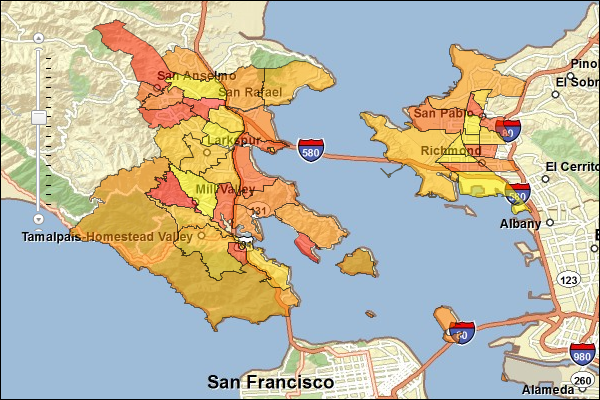
You can create a Target Penetration Map based on a selection of target segments. The Target Penetration Map illustrates geography locations that have high percent penetration of selected segments. This map helps you find areas of your target segments. You can use this map to direct your marketing efforts or locate a new site selection in areas where there are high concentrations of your target segments. The image below illustrates how this map may look.
With this endpoint, the AnalysisExtent parameter specifies the market area to thematically shade locations in, the SegmentationBase parameter specifies the base for assignment segments to geography sites, the SegmentationLevel parameter specifies the ID of a segmentation level, and the SelectedSegments parameter specifies the list of IDs of Tapestry segments of your interest.
Usage Tips
• To best determine what segments to include in the Target Penetration Map, you should analyze the output from the Customer Tapestry Profile Report.
• The segmentation base can be generated using total adult population or total households.
• Total adult population includes individuals 18 years or older.
• You may want to create a Game Plan Chart to help guide you in the selection of your segments.
Example Usage
The example below generates a Target Penetration Map output layer describing areas of interest within an analysis extent. The areas are filtered by a dominant market tapestry segment code equal to a specified value.
NOTE: See Get Segments lookup operation to query available Tapestry segments.
Response
{
  "results":
  [
    {
      "paramName":"OutputFeatureClass",
      "dataType":"GPFeatureRecordSetLayer",
      "value":
      {
        "geometryType":"esriGeometryPolygon",
        "spatialReference":
        {
          "wkid":4326
        },
        "fieldAliases":
        {
          "OBJECTID":"Object ID",
          "NAME":"NAME",
          "ID":"ID",
          "HH01":"HHs:Top Rung",
          "HH02":"HHs:Suburban Splendor",
          "HH03":"HHs:Connoisseurs",
          "HH04":"HHs:Boomburbs",
          "HH05":"HHs:Wealthy Seaboard Suburbs",
          "HH06":"HHs:Sophisticated Squires",
          "HH07":"HHs:Exurbanites",
          "HH08":"HHs:Laptops and Lattes",
          "HH09":"HHs:Urban Chic",
          "HH10":"HHs:Pleasant-Ville",
          "HH11":"HHs:Pacific Heights",
          "HH12":"HHs:Up and Coming Families",
          "HH13":"HHs:In Style",
          "HH14":"HHs:Prosperous Empty Nesters",
          "HH15":"HHs:Silver and Gold",
          "HH16":"HHs:Enterprising Professionals",
          "HH17":"HHs:Green Acres",
          "HH18":"HHs:Cozy and Comfortable",
          "HH19":"HHs:Milk and Cookies",
          "HH20":"HHs:City Lights",
          "HH21":"HHs:Urban Villages",
          "HH22":"HHs:Metropolitans",
          "HH23":"HHs:Trendsetters",
          "HH24":"HHs:Main Street USA",
          "HH25":"HHs:Salt of the Earth",
          "HH26":"HHs:Midland Crowd",
          "HH27":"HHs:Metro Renters",
          "HH28":"HHs:Aspiring Young Families",
          "HH29":"HHs:Rustbelt Retirees",
          "HH30":"HHs:Retirement Communities",
          "HH31":"HHs:Rural Resort Dwellers",
          "HH32":"HHs:Rustbelt Traditions",
          "HH33":"HHs:Midlife Junction",
          "HH34":"HHs:Family Foundations",
          "HH35":"HHs:International Marketplace",
          "HH36":"HHs:Old and Newcomers",
          "HH37":"HHs:Prairie Living",
          "HH38":"HHs:Industrious Urban Fringe",
          "HH39":"HHs:Young and Restless",
          "HH40":"HHs:Military Proximity",
          "HH41":"HHs:Crossroads",
          "HH42":"HHs:Southern Satellites",
          "HH43":"HHs:The Elders",
          "HH44":"HHs:Urban Melting Pot",
          "HH45":"HHs:City Strivers",
          "HH46":"HHs:Rooted Rural",
          "HH47":"HHs:Las Casas",
          "HH48":"HHs:Great Expectations",
          "HH49":"HHs:Senior Sun Seekers",
          "HH50":"HHs:Heartland Communities",
          "HH51":"HHs:Metro City Edge",
          "HH52":"HHs:Inner City Tenants",
          "HH53":"HHs:Home Town",
          "HH54":"HHs:Urban Rows",
          "HH55":"HHs:College Towns",
          "HH56":"HHs:Rural Bypasses",
          "HH57":"HHs:Simple Living",
          "HH58":"HHs:NeWest Residents",
          "HH59":"HHs:Southwestern Families",
          "HH60":"HHs:City Dimensions",
          "HH61":"HHs:High Rise Renters",
          "HH62":"HHs:Modest Income Homes",
          "HH63":"HHs:Dorms to Diplomas",
          "HH64":"HHs:City Commons",
          "HH65":"HHs:Social Security Set",
          "HH66":"HHs:Unclassified",
          "Penetration":"Penetration"
        },
        "fields":
        [
          {
            "name":"OBJECTID",
            "type":"esriFieldTypeOID",
            "alias":"Object ID"
          },
          ...
          {
            "name":"Penetration",
            "type":"esriFieldTypeDouble",
            "alias":"Penetration"
          }
        ],
        "features":
        [
          {
            "geometry":
            {
              "rings":
              [
                [
                  [
                    -122.367922,
                    37.830047
                  ],
                  ...
                  [
                    -122.367922,
                    37.830047
                  ]
                ],
                ...
                [
                  [
                    -122.420391,
                    37.863433
                  ],
                  ...
                  [
                    -122.420391,
                    37.863433
                  ]
                ]
              ],
              "spatialReference":
              {
                "wkid":4326
              }
            },
            "attributes":
            {
              "OBJECTID":1,
              "NAME":"060750179.02",
              "ID":"06075017902",
              "HH01":0,
              "HH02":0,
              "HH03":0,
              "HH04":0,
              "HH05":0,
              "HH06":0,
              "HH07":0,
              "HH08":0,
              "HH09":0,
              "HH10":0,
              "HH11":0,
              "HH12":0,
              "HH13":0,
              "HH14":0,
              "HH15":0,
              "HH16":0,
              "HH17":0,
              "HH18":0,
              "HH19":0,
              "HH20":0,
              "HH21":0,
              "HH22":0,
              "HH23":0,
              "HH24":0,
              "HH25":0,
              "HH26":0,
              "HH27":0,
              "HH28":0,
              "HH29":0,
              "HH30":0,
              "HH31":0,
              "HH32":0,
              "HH33":0,
              "HH34":0,
              "HH35":0,
              "HH36":0,
              "HH37":0,
              "HH38":0,
              "HH39":731,
              "HH40":0,
              "HH41":0,
              "HH42":0,
              "HH43":0,
              "HH44":0,
              "HH45":0,
              "HH46":0,
              "HH47":0,
              "HH48":0,
              "HH49":0,
              "HH50":0,
              "HH51":0,
              "HH52":0,
              "HH53":0,
              "HH54":0,
              "HH55":0,
              "HH56":0,
              "HH57":0,
              "HH58":0,
              "HH59":0,
              "HH60":0,
              "HH61":0,
              "HH62":0,
              "HH63":0,
              "HH64":0,
              "HH65":0,
              "HH66":0,
              "Penetration":0
            }
          },
          ...
          {
            "geometry":
            {
              "rings":
              [
                [
                  [
                    -122.3446,
                    37.935352
                  ],
                  ...
                  [
                    -122.3446,
                    37.935352
                  ]
                ]
              ],
              "spatialReference":
              {
                "wkid":4326
              }
            },
            "attributes":
            {
              "OBJECTID":46,
              "NAME":"060133810.00",
              "ID":"06013381000",
              "HH01":0,
              "HH02":0,
              "HH03":0,
              "HH04":0,
              "HH05":0,
              "HH06":0,
              "HH07":0,
              "HH08":0,
              "HH09":0,
              "HH10":0,
              "HH11":0,
              "HH12":0,
              "HH13":0,
              "HH14":0,
              "HH15":0,
              "HH16":0,
              "HH17":0,
              "HH18":0,
              "HH19":0,
              "HH20":0,
              "HH21":0,
              "HH22":0,
              "HH23":0,
              "HH24":282,
              "HH25":0,
              "HH26":0,
              "HH27":0,
              "HH28":0,
              "HH29":0,
              "HH30":0,
              "HH31":0,
              "HH32":0,
              "HH33":0,
              "HH34":450,
              "HH35":280,
              "HH36":0,
              "HH37":0,
              "HH38":0,
              "HH39":0,
              "HH40":0,
              "HH41":0,
              "HH42":0,
              "HH43":0,
              "HH44":0,
              "HH45":1000,
              "HH46":0,
              "HH47":0,
              "HH48":0,
              "HH49":0,
              "HH50":0,
              "HH51":0,
              "HH52":0,
              "HH53":0,
              "HH54":0,
              "HH55":0,
              "HH56":0,
              "HH57":0,
              "HH58":0,
              "HH59":0,
              "HH60":0,
              "HH61":0,
              "HH62":0,
              "HH63":0,
              "HH64":0,
              "HH65":0,
              "HH66":0,
              "Penetration":0
            }
          }
        ]
      }
    },
    {
      "paramName":"PenetrationMapReport.PDF",
      "dataType":"GPDataFile",
      "value":
      {
        "url":"http://localhost/arcgisoutput/_ags_TB1EDD5A724951A1F7C890F26239AD.pdf"
      }
    }
  ],
  "messages":
  [
  ]
}
NOTE: The response has been abbreviated where "..." is noted.
JSON Response Example Rendered with the ArcGIS API for JavaScript
See Also