


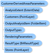
 Object Model
Syntax
Remarks
The analysis can be restricted to an analysis extent if the analysisExtent parameter is specified. The optional singleStoreID parameter restricts the analysis to a single store of the store layer.
Tuning parameters:
- The
HullTypeparameter specifies a type of hull to be created around every store location. - If the
CustomerWeightFieldparameter is specified, the percentages of customers are calculated using values of this field as the weight. - If the
CutOffDistanceparameter is specified, the customers that lie beyond this distance from associated stores are excluded from the analysis. TheCutOffUnitsparameter should be specified in this case. - If the
UseCustomersCentroidparameter is true, the customers’ centroids are used instead of stores as centers of trade areas. - If the
Donutparameter is true, the donut trade areas are created.
Output options for this task include rendering an output image (OutputTypes.GetMapImage), creating a feature class for subsequent analysis (OutputTypes.GetFeatureClass), and/or creating a report (OutputTypes.GetReport). If no output options are specified, the required output options are specified as follows. If the RenderingParameters parameter is specified, the image output is requested. If the ReportOptions parameter is specified, the report is requested. If the OutputAnalysisItem parameter is specified, the output analysis feature class will be stored in the repository. If RenderingParameters, ReportOptions, and OutputAnalysisItem parameters are missing, the feature class output is requested.
Example
| C# |  Copy Code Copy Code |
|---|---|
CustomerDerivedAreasParameters parameters = new CustomerDerivedAreasParameters(); // The PointLayer type could take either data as // ESRI.ArcGIS.Client.Tasks.FeatureSet, ESRI.ArcGIS.Client.BAServer.FolderItem, // or a list of ESRI.ArcGIS.Client.BACore.PointRecord items, e.g. //List<PointRecord> points = new List<PointRecord>() { // new PointRecord("Store 1", "Steiner St. & Geary Blvd", "1", 37.78415, -122.4346)}; // Set Stores as a list of PointRecord using implicit cast operator. parameters.Stores = points; // The StoreIDField parameter is ignored if stores are specified as a list of PointRecord. //parameters.StoreIDField = "STORE_ID"; // Set Customers with a valid data type. parameters.Customers = customers; // Set the field name to link customers with a store. parameters.CustomerLinkField = "STORE_ID"; // Optionally restrict analysis to ExtendData object specified with myExtent. //parameters.AnalysisExtent = myExtent; // Set thresholds for percentage of customers. parameters.Percentages = new List<double>() { 20,40,60 }; // False is the default value for Donut. //parameters.Donut = false; // HullType.Simple is the default value for HullType. parameters.HullType = HullType.Detailed; // true is the default value for UseCustomersCentroid. //parameters.UseCustomersCentroid = true; // Set cut off distance threshold value. parameters.CutOffDistance = 10; // Miles is the default value for CutOffUnits with CutOffDistance having the actual value in those units. //parameters.CutOffUnits = esriUnits.esriMiles; customerDerivedAreasTask.ExecuteAsync(parameters, new AsyncResponder(resultHandler, faultHandler)); | |
Inheritance Hierarchy
System.Object
ESRI.ArcGIS.Client.BACore.Client.BATaskParameters
ESRI.ArcGIS.Client.BACore.Client.SummaryReportParameters
ESRI.ArcGIS.Client.BAServer.Tasks.TradeAreas.TradeAreaTaskParameters
ESRI.ArcGIS.Client.BAServer.Tasks.TradeAreas.CustomerDerivedAreasParameters
Requirements
Target Platforms: Windows 98, Windows NT 4.0, Windows Millennium Edition, Windows 2000, Windows XP Home Edition, Windows XP Professional, Windows Server 2003 family, Windows Vista, Windows Server 2008 family