O V E R V I E W
Geocoding is the process of assigning a location,
usually in the form of coordinate values (points), to an address by comparing
the descriptive location elements in the address to those present in the
reference material. Addresses come in many forms, ranging from the common
address format of a house number followed by the street name and succeeding
information to other location descriptions, such as postal zone or census
tract. An address includes any type of information
that distinguishes a place.
Geocode services provide the ability to assign locations to address attribute
information. You can use a geocode service to:
Assign a location to address attributes
Generate a list of candidate locations for an attribute
Assign address attributes to a location (reverse geocoding)
Modify input and output properties associated with the geocode process
http://<Web
Server Hostname>/<ArcGIS
Instance>/services/<ServiceName>/GeocodeServer?wsdl
Working with geocode services
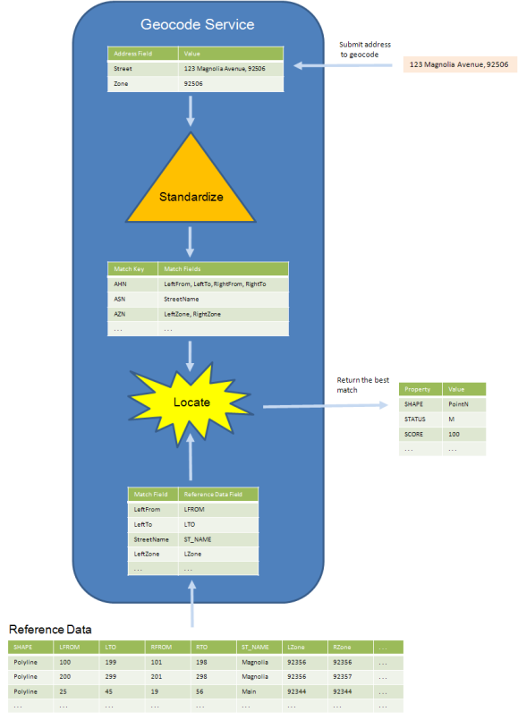
The geocode process involves a number of steps. The following diagram provides an overview of a simple geocode operation (call to GeocodeAddress) from the perspective of a geocode service. The address input is packaged by a developer in a set of address fields defined by the service. Some or all of the address fields are passed to an internal standardizer which standardizes, or parses, address content using a set of rules defined by a standardizer. Each parsed address item is associated with a match key. The match key relates address input and match fields in the reference data. The geocode service uses this relationship, one match field per reference data field, to generate a location. The score of the match is determined by the weights assigned to the match keys, required fields, and spelling sensitivities. The matched location, match field values, standardized address, and score can be returned from the operation.
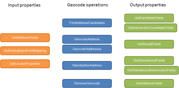
The geocode server proxy includes a set
of methods to initiate geocode operations and a set of methods to provide
information about inputs and outputs to an operation. The
chart below provides an overview of the all geocode server methods and
their relationship to the role they serve. Input
properties to geocode operations are returned from GetAddressFields, GetDefaultInputFieldMapping,
and GetLocatorProperties. For example, GetAddressFields
returns a set of fields used to package an input address to most geocode
operations. The geocode operations themselves are
methods on the proxy. FindAddressCandidates returns
many match candidates for a single address input. Geocode
address returns the best match for a single address input. GeocodeAddresses
locates a table of addresses and returns the best match for each input.
StandardizeAddress returns an input address standardized
using the geocode service standardizer. ReverseGeocode
returns the nearest address to an input point. A
set of methods return information on the output properties from geocode
operation results. The appropriate output methods
are grouped with the geocode operation. For example,
results from a call to FindAddressCandidates are packaged in a set of
records whose field names and types are defined by GetCandidateFields.
Methods
|
Proxy method |
Description |
|
Geocodes a single address and returns multiple results (candidates).
| |
|
Geocodes a single address and returns a single result.
| |
|
Geocodes multiple addresses and returns a single match result for each address.
| |
|
Fields used to define address information submitted to a geocode service.
| |
|
Fields contained in a list of candidates returned from geocoding an address using the FindAddressCandidates() method.
| |
|
Acceptable field name mappings (inputs) to address fields in a geocode service.
| |
|
Fields contained in a list of candidates returned
from geocoding an intersection with the FindAddressCandidates() method. | |
|
The default properties of a geocode service (locator). Often used to modify characteristics of a geocode operation.
| |
|
Fields contained in the results of a geocode operation using the GeocodeAddress() and GeocodeAddresses() methods.
| |
|
Fields contained in an standardized address returned from the StandardizeAddress() method.
| |
|
Fields contained in a standardized intersection returned from the StandardizeAddress() method.
| |
|
Returns the address closest to the given point,
and within a specified search distance. | |
|
Standardizes an address using rules defined within the geocode service.
|