
Unlike the Map Web Part, which is designed to provide extensive configuration options, the Geolist is meant to primarily be used without requiring any configuration. Yet the Geolist does have three simple properties that can optionally be configured - the map the Geolist is associated with, auto-scroll, and filter by map view. These properties are available on the Settings dialog, which you can open by clicking the Settings button. The Settings button is outlined with a red rectangle in the image below:

The following image and table explain how to use the Settings dialog:
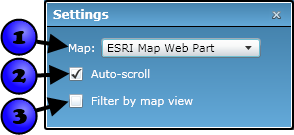
| Number | Setting | Description |
|---|---|---|
| 1 | Associated map | The Map Web Part that the Geolist is linked to. The Geolist will display SharePoint, ArcGIS Server, and MapIt Spatial Data Service datasets that have been added to the associated Map Web Part. You will only need to set this property if you have more than one Map Web Part on the same page |
| 2 | Auto-scroll | If checked, then the Geolist automatically scrolls to a record when you move the mouse over the corresponding item in the map. This setting is checked by default. |
| 3 | Filter by map view | If checked, items are shown in the Geolist only if they are within the current extent of the associated map. The items will be updated every time the map extent is changed. This setting is unchecked by default. |
These settings can be changed regardless of whether the Geolist Web Part is being edited, and the Geolist's behavior will update immediately. But to save changes you make so that they persist every time the Geolist is loaded, you must change these settings while modifying the web part. For more information on modifying web parts, refer to the Edit Web Parts topic.