Used in
CONFIG REQUEST RESPONSEServers
ImageParent elements
IMAGE PROPERTIESSyntax
| <LEGEND | Attribute Description Table |
When parent element is IMAGE: file="string" type="gif | jpg | png | png8" url="string" When parent element is PROPERTIES: antialiasing="true | false" [true] autoextend="true | false" [false] backgroundcolor="0,0,0 - 255,255,255" cansplit="true | false" [false] cellspacing="integer" [2] columns="integer" [1] display="true | false" [true] font="Any system font" [Arial] height="1 - NNN" [300] layerfontcolor="0,0,0 - 255,255,255" [0,0,0] layerfontsize="1 - NNN" [10] layerfontstyle="regular | bold | italic | underline | outline | bolditalic" [bold] reverseorder="true | false" [false] splittext="string" [(cont)] swatchheight="integer" [14] swatchwidth="integer" [18] title="string" titlefontcolor="0,0,0 - 255,255,255" [0,0,0] titlefontsize="1 - NNN" [12] titlefontstyle="regular | bold | italic | underline | outline | bolditalic" [bold] transcolor="0,0,0 - 255,255,255" valuefontcolor="0,0,0 - 255,255,255" [0,0,0] valuefontsize="1 - NNN" [8] valuefontstyle="regular | bold | italic | underline | outline | bolditalic" [bold] width="1 - NNN" [125] > When parent element is IMAGE: No Child Elements When parent element is PROPERTIES and using Image Server: (m)<LAYERS... /> </LEGEND > | |
| (m): Child element can be used multiple times. | |
Description
Defines the map's legend when using an Image Service.Restrictions
- When using an ArcIMS HTML Viewer, ArcIMS Java Viewer, ArcExplorer-Java Edition, or any other client using the ArcIMS Servlet Connector, the LEGEND element is restricted in an IMAGE response. The attribute file is not returned.
This restriction can be lifted by setting the property spatialServer.AllowResponsePath to true in esrimap_prop. This property file is found in the same directory as the ArcIMS Servlet Connector. For more information on the location of esrimap_prop and its properties, see ArcIMS Help.
This restriction applies only when the ArcIMS Servlet Connector is used. It does not apply when any other connector, the Web ADF for the Microsoft .NET Framework, or the Web ADF for the Java Platform is used. - Valid only with Image Services in an ArcIMS HTML Viewer or other HTML implementation.
- Legend image output can be streamed in Base64 encoded format and returned as part of the IMAGE response. This is an alternative to generating images in an output directory. The following restrictions apply:
- Valid only with Image Services.
- Valid only when using the Java Connector, Web ADF for the Microsoft .NET Framework, or Web ADF for the Java Platform. Streamed images are not supported with the ActiveX, ColdFusion, or Servlet Connectors.
- In the map configuration file, the following line must be included in the PROPERTIES section: <OUTPUT method="stream" />.
- When creating an Image Service in ArcIMS Administrator, the Directory Location and HTTP Location must both be filled out. A dummy location can be used rather than pointing to an actual directory.
- In an IMAGE response, if a legend image is streamed, the attributes file and url are not included and are not required.
Notes
- If LEGEND is defined in a map configuration file, then a legend is always generated during a GET_IMAGE request even if no legend is defined in the request.
- To remove layers from the legend list, use LAYERS.
- The following table shows which attributes are available for setting the size and font for the title and individual layers.
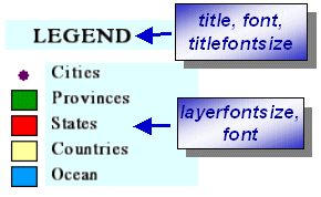
Attributes available when using an Image Service and no layers contain a value map. 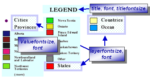
Attributes available when using an Image Service and at least one layer contains a value map. - For a comprehensive overview of using LEGEND, including more examples, see Using GET_IMAGE and IMAGE with Image Services.
Attribute Descriptions for LEGEND
When parent element is IMAGE:
| Attribute | Usage |
|---|---|
| file | Full pathname and filename for location of legend image generated by the ArcIMS Spatial Server. Image is written to the ArcIMS Spatial Server's output directory by default. UNC pathnames are valid (\\myComputer\arcims\output). |
| type | Returned when OUTPUT method="stream" in a map configuration file for Image Services. Valid only when the Java Connector, the Web ADF for the Microsoft .NET Framework, or the Web ADF for the Java Platform is used. |
| url | URL used by client to retrieve legend image. |
When parent element is PROPERTIES:
| Attribute | Usage |
|---|---|
| antialiasing | Used to make edges of labels and symbols smoother. When set to "true", antialiasing is active. Note that the time to generate a map may significantly increase when antialiasing is turned on. |
| autoextend | If "true", automatically extends legend vertically past size specified in height, if needed. |
| backgroundcolor | Legend?s background color using RGB values. |
| cansplit | Allows splitting of valuemap layers between columns. |
| cellspacing | Defines number of pixels to pad between entries. |
| columns | Defines number of columns in legend. |
| display | Turns legend on or off. |
| font | Font for title. The name is case sensitive. If font name uses "&", use "&" instead. For example, ESRI Transportation & Civic should be written as ESRI Transportation & Civic. For Feature Services, the font must reside on the client machine or else the system default font is used. |
| height | Legend height in pixels. |
| layerfontcolor | Font color for the layer lables. |
| layerfontsize | Font size for the layer labels. |
| layerfontstyle | Font color for the layer labels. |
| reverseorder | Reverse order of layers. |
| splittext | Text that displays in bottom of a column if a valuemap is carried over into the next column. |
| swatchheight | Height of the symbol swatch in pixels. |
| swatchwidth | Width of the symbol swatch in pixels. |
| title | Title of legend. |
| titlefontcolor | Font color for the legend title. |
| titlefontsize | Font size for the legend title. |
| titlefontstyle | Font color for the legend title. |
| transcolor | Transparency color using RGB values. White is 255,255,255. |
| valuefontcolor | Font color for the value map labels. |
| valuefontsize | Font size for the value map labels. |
| valuefontstyle | Font color for the value map labels. |
| width | Legend width in pixels. |
Examples for LEGEND
Example 1: When in an IMAGE response and LEGEND is restricted.| <?xml version="1.0" encoding="UTF8"?> <ARCXML version="1.1"> <RESPONSE> <IMAGE> <LEGEND url="http://mymachine.domain.com/output/Iextensions_MYMACHINE4094163.jpg" /> </IMAGE> </RESPONSE> </ARCXML> |
Example 2: When in an IMAGE response with no restrictions on LEGEND.
| <?xml version="1.0" encoding="UTF8"?> <ARCXML version="1.1"> <RESPONSE> <IMAGE> <LEGEND file="D:\ArcIMS\output\Iextensions_MYMACHINE4094163.jpg" url="http://mymachine.domain.com/output/Iextensions_MYMACHINE4094163.jpg" /> </IMAGE> </RESPONSE> </ARCXML> |
Example 3: GET_IMAGE request where layers with ID of "0" and "1" are removed from the legend list.
| <?xml version="1.0" encoding="UTF-8"?> <ARCXML version="1.1"> <REQUEST> <GET_IMAGE> <PROPERTIES> <LEGEND title="Legend" font="Arial" autoextend="true" columns="1" width="170" height="300" backgroundcolor="255,255,0" > <LAYERS> <LAYER id="0"/> <LAYER id="1"/> </LAYERS> </LEGEND> <DRAW map="false"/> </PROPERTIES> </GET_IMAGE> </REQUEST> </ARCXML> |
Example 4: Map configuration file where layers with ID of "0" and "1" are removed from the legend list.
| <?xml version="1.0" encoding="UTF-8"?> <ARCXML version="1.1"> <CONFIG> <ENVIRONMENT> <LOCALE country="US" language="en" variant="" /> <UIFONT color="0,0,0" name="Arial" size="12" style="regular" /> <SCREEN dpi="96" /> </ENVIRONMENT> <MAP dynamic="true" > <PROPERTIES> <ENVELOPE minx="-180.0" miny="-90.0" maxx="180.0" maxy="90.0" name="Initial_Extent" /> <MAPUNITS units="decimal_degrees" /> <FILTERCOORDSYS id="4326" /> <FEATURECOORDSYS id="4326"/> <LEGEND title="Legend" font="Arial" autoextend="true" columns="1" width="170" height="300" backgroundcolor="255,255,0" > <LAYERS> <LAYER id="0"/> <LAYER id="1"/> </LAYERS> </LEGEND> </PROPERTIES> <WORKSPACES> <SHAPEWORKSPACE name="shp_ws-0" directory="<path to WORLD ESRIDATA>" /> <SHAPEWORKSPACE name="shp_ws-2" directory="<path to USA ESRIDATA>" /> <SHAPEWORKSPACE name="shp_ws-3" directory="<path to CANADA ESRIDATA>" /> </WORKSPACES> <LAYER type="featureclass" name="WORLD30" visible="true" id="0"> <DATASET name="WORLD30" type="polygon" workspace="shp_ws-0" /> <SIMPLERENDERER> <SIMPLEPOLYGONSYMBOL filltype="solid" fillcolor="0,153,255" /> </SIMPLERENDERER> </LAYER> <LAYER type="featureclass" name="CNTRY94" visible="true" id="1"> <DATASET name="CNTRY94" type="polygon" workspace="shp_ws-0" /> <SIMPLERENDERER> <SIMPLEPOLYGONSYMBOL filltype="solid" fillcolor="255,255,153" /> </SIMPLERENDERER> </LAYER> <LAYER type="featureclass" name="United States" visible="true" id="2"> <DATASET name="STATES" type="polygon" workspace="shp_ws-2" /> <SIMPLERENDERER> <SIMPLEPOLYGONSYMBOL filltype="solid" fillcolor="255,0,0" /> </SIMPLERENDERER> </LAYER> <LAYER type="featureclass" name="Canada" visible="true" id="3"> <DATASET name="province" type="polygon" workspace="shp_ws-3" /> <SIMPLERENDERER> <SIMPLEPOLYGONSYMBOL filltype="solid" fillcolor="0,153,0" /> </SIMPLERENDERER> </LAYER> <LAYER type="featureclass" name="World Cities" visible="true" id="4"> <DATASET name="CITIES" type="point" workspace="shp_ws-0" /> <SIMPLERENDERER> <SIMPLEMARKERSYMBOL color="102,0,102" width="8.0" /> </SIMPLERENDERER> </LAYER> </MAP> </CONFIG> </ARCXML> |
Example 5: When used in an IMAGE response and image is streamed using Base64 encoding.
| <?xml version="1.0" encoding="UTF-8"?> <ARCXML version="1.1"> <RESPONSE> <IMAGE> <ENVELOPE minx="-180" miny="-135" maxx="180" maxy="135" /> <OUTPUT type="jpg">/9j/4AAQSk ... ZJRgABZ</OUTPUT> <LEGEND type="jpg" >/9j/4AAQSkZJRgABAQA ... UDBAQEAZ</LEGEND> </IMAGE> </RESPONSE> </ARCXML> |
Back to top