Used in
REQUESTServers
Image Query FeatureParent elements
QUERY SPATIALFILTER SPATIALQUERYSyntax
| <BUFFER | Attribute Description Table |
When using Feature Server: (r)distance="double" bufferunits="decimal_degrees | miles | feet | kilometers | meters" [MAPUNITS defined in PROPERTIES] When using Image Server: (r)distance="double" bufferunits="decimal_degrees | miles | feet | kilometers | meters" [MAPUNITS defined in PROPERTIES] project="true | false" [true] > When parent element is SPATIALFILTER: No Child Elements When parent element is SPATIALQUERY: <SPATIALQUERY... /> <TARGETLAYER... /> </BUFFER > | |
| (r): Attribute or child element is required. | |
Description
Builds a buffer region around selected features.Restrictions
- SPATIALQUERY used in BUFFER cannot contain another BUFFER inside.
Notes
- BUFFER can be used three ways:
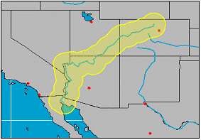
To buffer a region around one or more selected features, use BUFFER inside a SPATIALQUERY. In this example, the Colorado River is buffered.
<LAYER type="featureclass" name="theRiverBuffer" id="RivBuf">
<DATASET fromlayer="Rivers" />
<SPATIALQUERY where="NAME='Colorado'">
<BUFFER distance="80" bufferunits="MILES" />
</SPATIALQUERY>
<SIMPLERENDERER>
<SIMPLEPOLYGONSYMBOL fillcolor="255,255,0" filltransparency=".3" boundarycolor="255,255,0" boundarywidth="2" />
</SIMPLERENDERER>
</LAYER>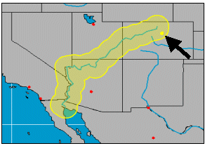
To select features from the same or another layer that fall within the buffer region, use TARGETLAYER as a child element. In this example, cities within 80 miles of the Colorado River are selected. (The buffer in the picture is shown for reference. With this request, only selected cities would display. To highlight the cities and show the buffer, both the following and preceding LAYER examples must be used in a request.)
<LAYER type="featureclass" name="theRiverBuffer" id="RivBuf">
<DATASET fromlayer="Rivers" />
<SPATIALQUERY where="NAME='Colorado'">
<BUFFER distance="80" bufferunits="MILES" >
<TARGETLAYER id="Cities" />
</BUFFER>
</SPATIALQUERY>
<SIMPLERENDERER>
<SIMPLEMARKERSYMBOL color="255,255,0" width="6" />
</SIMPLERENDERER>
</LAYER>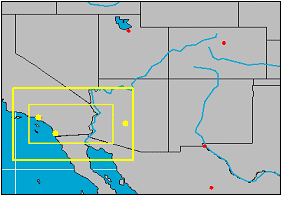
To use a buffer as a selection tool. BUFFER is used around a defined filter within SPATIALFILTER. In this example, BUFFER is used to buffer around an envelope. The inner yellow box is the original envelope. The outer yellow box is the buffer filter. Note that these boxes would not normally display; only the selected items within the filter. br>
<LAYER type="featureclass" name="theEvelopeBuffer" id="EnvBuf" >
<DATASET fromlayer="Cities" />
<SPATIALQUERY where="POPULATION > 1000000" >
<SPATIALFILTER relation="area_intersection">
<ENVELOPE minx="-119" miny="32" maxx="-113" maxy="35" />
<BUFFER distance="100" bufferunits="MILES" />
</SPATIALFILTER>
</SPATIALQUERY>
<SIMPLERENDERER>
<SIMPLEMARKERSYMBOL color="255,255,0" width="6" />
</SIMPLERENDERER>
</LAYER> - In a GET_FEATURES request, when SPATIALQUERY is a parent element to BUFFER and subfields is included, the field #SHAPE# or #ALL# must be included in the subfields list.
- A buffer distance of 0 can be used on polygon features. If a buffer distance of 0 is used with line or point features, no data is returned.
- Buffer results may be inaccurate on unprojected data. It is recommended to project data before applying a buffer.
- FILTERCOORDSYSYS and FEATURECOORDSYS must be included inside TARGETLAYER when you need to
- project the ENVELOPE for features returned in the target layer (GET_FEATURES envelope="true")
- project the global envelope for the returned features (GET_FEATURES globalenvelope="true")
- project geometry for features in the target layer (GET_FEATURES geometry="true")
Attribute Descriptions for BUFFER
| Attribute | Usage |
|---|---|
| bufferunits | Specifies units that apply to buffer. |
| distance | Buffer area width in buffer units. |
| project | Generated buffers are projected if FEATURECOORDSYS is in the map configuration file or a request. If project is set to false, the buffer is not projected. Known limit. When projecting buffers and TARGETLAYER is used, FEATURECOORDSYS and FILTERCOORDSYS must be explicitly defined inside TARGETLAYER even if they are included in the map configuration file. Otherwise, the buffer will not project as expected. The coordinate system elements do not need to be included in a request when TARGETLAYER is not present. |
Examples for BUFFER
Example 1: When in a GET_FEATURES request.| <?xml version="1.0" encoding="UTF-8" ?> <ARCXML version="1.1"> <REQUEST> <GET_FEATURES featurelimit="25" beginrecord="0" outputmode="xml" geometry="false" envelope="true" compact="true"> <LAYER id="2" /> <!-- states --> <SPATIALQUERY subfields="#SHAPE# NAME"> <BUFFER distance="1" > <TARGETLAYER id="4" /> <!-- cities --> <SPATIALQUERY subfields="NAME" /> </BUFFER> <SPATIALFILTER relation="area_intersection" > <ENVELOPE minx="-16154208.3772906" miny="-4165319.9729724" maxx="-4904885.23874079" maxy="4271672.38093997" /> </SPATIALFILTER> </SPATIALQUERY> </GET_FEATURES> </REQUEST> </ARCXML> |
Example 2: When in a GET_IMAGE request. Shows selected features and buffer. Note in this example that the DATASET fromlayer is "CITIES". This refers to the LAYER id in the map configuration file, not the LAYER name.
| <?xml version="1.0" encoding="UTF-8"?> <ARCXML version="1.1"> <REQUEST> <GET_IMAGE> <PROPERTIES> <ENVELOPE minx="867805.08306143" miny="6771243.45626185" maxx="1576642.8482793" maxy="7302871.78017525"/> </PROPERTIES> <LAYER type="featureclass" name="theBufferTarget" visible="true" id="buffertarget"> <DATASET fromlayer="CITIES"/> <SPATIALQUERY> <BUFFER distance="100" bufferunits="miles"> <TARGETLAYER id="CITIES"/> </BUFFER> <SPATIALFILTER relation="area_intersection"> <ENVELOPE minx="867805.08306143" miny="6771243.45626185" maxx="1576642.8482793" maxy="7302871.78017525"/> </SPATIALFILTER> </SPATIALQUERY> <SIMPLERENDERER> <SIMPLEMARKERSYMBOL color="255,0,0" /> </SIMPLERENDERER> </LAYER> <LAYER type="featureclass" name="theBuffer" visible="true" id="buffer"> <DATASET fromlayer="CITIES"/> <SPATIALQUERY> <BUFFER distance="100" bufferunits="miles" /> <SPATIALFILTER relation="area_intersection"> <ENVELOPE minx="867805.08306143" miny="6771243.45626185" maxx="1576642.8482793" maxy="7302871.78017525"/> </SPATIALFILTER> </SPATIALQUERY> <SIMPLERENDERER> <SIMPLEPOLYGONSYMBOL fillcolor="100,100,100" filltype="solid" filltransparency="0.5" /> </SIMPLERENDERER> </LAYER> </GET_IMAGE> </REQUEST> </ARCXML> |
Example 3: When projecting features in the target layer or when a projected envelope or global envelope is desired.
| <?xml version="1.0" encoding="UTF-8" ?> <ARCXML version="1.1"> <REQUEST> <GET_FEATURES outputmode="xml" geometry="true" envelope="true" checkesc="true" globalenvelope="true"> <LAYER id="0" ftype="polygon" /> <SPATIALQUERY where="STATE_NAME='Nevada'"> <BUFFER distance="0" bufferunits="miles" project="true" > <TARGETLAYER id="1" /> <SPATIALQUERY subfields="CITY_NAME #SHAPE#"> <FEATURECOORDSYS id="102008" /> <FILTERCOORDSYS id="102008" /> </SPATIALQUERY> </BUFFER> </SPATIALQUERY> </GET_FEATURES> </REQUEST> </ARCXML> |
Back to top